
1934 USGS Nautical Chart


Aerial Photography was not yet used widely and this map seems to be based on interviews with the land holders. This makes it accurate in some ways and inaccurate in others.
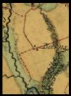
This circle represent the fact that Monquin and Pampatike Creek come from the same creek.
It was odd to see at
first, but makes sense if the information
came from an interview.
The fact that Dam Creek and Pamptaike connect, which used to be the same creek, again verifies the information that this chart is built from is oral. The history of these creeks is they were once the same creek. When the dike was built, The new mouth to Pampatike was built, so they have never been physically connected.
This branch of Pampatike has a dam on it at this time, so it is understandable as to why it is confused with the real Dam Creek.
Dam
Creek
Pampatike
Creek


Moncuin
Creek

“The Island” was
known as “Goodwins Island”