
1979 King William highway map

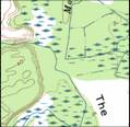

This county created map
confuses Monquin and Pampatike creek. The truth
is that Monquin feeds BOTH lower Monquin and Pampatike.
They intertwine at the top of the dike and the waters goes
in both directions. The map is wrong at the bottom
of the dike and draws Moncuin turning to the right when it
really goes to the left. This could be from maps
from the 30s even the creek was change by Frank Townsend
Sr. in the 60s.
The 1994 USGS map continues
with this mistake and does not draw
the connection.
Lower Monquin Creek
Goodwins Creek


Creek Connects at
this point


Piping Tree Creek is depicted
as a single creek even though it is now three
separate creeks.

Dike
