
1651
Jan Jansson (publisher)
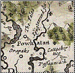
This map is the last mention of the name “Catachiptico.” Notice that it is not directly on the river, just like the island field


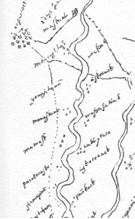
This map has no author but
has Jan Jansson listed as
the publisher. It names the river as “Iongtamind flu” which is a version of “Youghtanund.”
Important note- Only Zuniga
shows both Youghtanund and
Manskin at the same time and they are neighbors. It usually is Youghtanund in the early maps and Manskin in the later maps.
Next downstream is
“Cattachiptico” which is “the Island.”
These villages reduce in
number during the 1600s and coalece into 3 tribes- Manskin, Mattaponi and Pamoameck. The Manskin Indians probably originally came from the Manaskint village. At the time the Youchtanund dissapear from maps, the Manskin appear, so the Youghtanund probably have been combined into the Manskin.


1680 Morden
1608 Zuniga