
Manskin Anglicized to Manquin and Moncuin


Zuniga labled Totopotmoy Creek as Manaskint, but it was wrongly
translatd as Menaskunt, so no one made the naming connection. Langstron
called Totopotomov Creek Manskin creek. (They were
just across the creek). Next Herman labels the Manskin Indians as living on Guttin Isle, but historians discount Herman because they confuse his label of Manskin with the Manakin Indians who were 50 miles upriver. Historians at the time considered his label as erroneous. The Manskin Indians seem to
be one of the two villages that all the Pamunkey Indians coalesced into after the intrusion of white
settlers. After 1750, history lost the Manskin Indians as a
tribe. Is shows up in no lists of the villages
in current inventories.
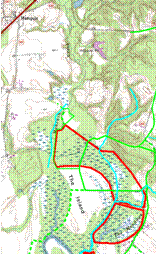
Martha McCartney relocates Opechancanoughs
village of Menmend as “the Island”
which later maps show as populated by Manskin Indians. But it has been in the old maps and new maps all along because it lives on in the creek and town
names. “Manskin Lodge” farm is still across from
Totopotomoy creek. The Manskin Indians that lived on “the Island”
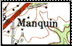
just below the town listed on
current USGS Maps as Manquin. And the creeks name is Moncuin creek which is a simple mispronunciation of Manskin. Right under our
noses but not recognized.
Conclusion is that Opechancanough is
likely to have been a Manskin Indian,
who were probably a renamed Youghtanund tribe, a sister
tribe to the Pamunkeys that has been lost to history.
