
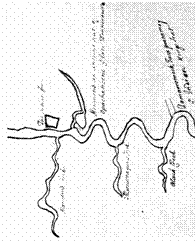

1662
Langston
Anthony Langston’s hand draw map almost
perfectly draws
Moncuin along side of
“The Island.”
”Manskind Creek: Totopotomoy Creek. This creek probably derived its earlier name from its proximity to the region called Manskin or Manskin Indian land, which, according to the maps of John Lederer (1672) and John Thornton (1698), lay opposite the mouth of the creek. By 1663 the stream became known as Totopotomoy Creek, in possible commemoration of that Pamunkey Indian leader who had lost his life defending the English.”
Martha
McCarthy 1984
He names Topotomoy creek as “Manskind Creek”

