Peninsula is Pamavnkee
“On the South side inhabit the
people of Youghtanund, who haue about 60 men for warres. On the North branch Mattapament, who
haue 30 men. Where
this
river is divided the Country is called Pamavnkee, and nourisheth neare 300 able men. About 25 myles
lower on the North side of
this river is Werawocomoco, where their
great King inhabited when I was delivered
him prisoner; ?
John Smith –
General Historie
The Penninsula is called Pamavnkee
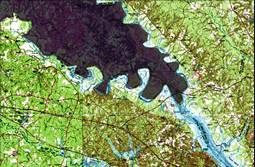

Pamavnkee
Youghtanund
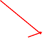
As Crow
flies, Island field is 32 miles from Werowocomoco and the tip of the peninsula is only 11 miles. So John Smith is referring to
the Peninsula as the Country called Pamavnkee in this
description, not a single point or village such at the Indian Reservation. He is making this measurement
from his own map while back in
England. So his measurement of About 25 miles is
not from a point to
point, but from a general area, that’s why he says “About”. The Pamunkey Indians live in many villages in the Peninsula
and Opechancanough moves
between them as need be. Opechancanough perceives a threat from the English and moves to “The Island” as his fortress.
Werowocomoco
25
miles
