
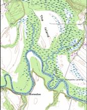
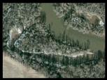
Horseshoe


Smith was Here

Some scholars
put Opechancanought at Matchut which is a few miles downstream from the Island in the early years of Jamestown. But sometime between 1607 and 1623 Opechancanough moved his headquarters to Menmend on the Island as indicated on the 1662 Langstom map.
“Captain
John Martin, who in 1623 crafted a plan for taking over Opechancanough's territory, said that he lived upon an island in the Pamunkey River. “
Martha Macartney- http://www.cr.nps.gov/history/online_books/jame1/moretti-langholtz/chap4.htm
There is an island in the middle of the river here.
The “Horseshoe” island does not show up on
modern USGS maps. So I believe the
historians read John Smiths
story, ran their finger down modern USGS maps of the Pamunkey until they found an island on the modern USGS map, and therefore placed this fight scene down river a few miles instead of on the “Island” and having the “Horseshoe Island” as the “Island in the middle of the river.
