
1608
Pedro de Zuniga


Menoughtas
Youghann
Menaskunt
Matunsk
Paroconosko
Unekent
Askocack
Washasatiack
Cattachiptico
(The Island )
Askococack


Current RT 360 Pumunkey
River bridge


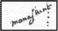


Traditionally listed as Menaskunt looks to me like Manaskint, very close to Manskin, and at the location of Totopotomoy
Creek
This map is the key image to the undisturbed village/tribe
distribution before reaction
to the colonist. It shows Youghann, Manaskint and Cattachiptico in the same map and all living contiguously.
